![]()
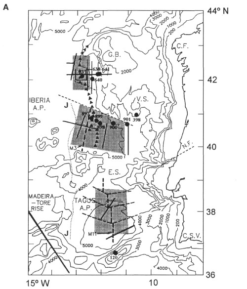
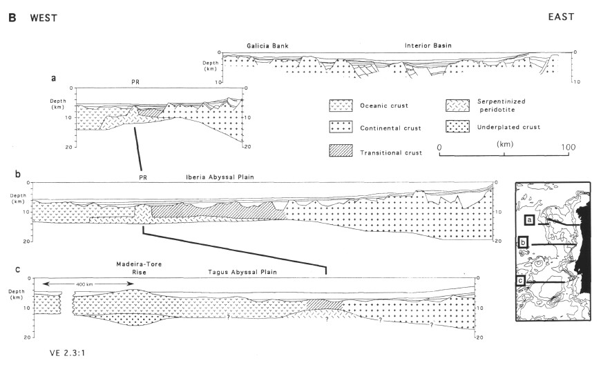
Figure 10. A. Bathymetric chart of the west Iberia Margin (after Lallemand et al., 1985; contours in meters) showing the main features in the region of the ocean-continent transition. Stippled area shows distribution of probable serpentinized peridotite at the base of the crust, based on observations along seismic refraction lines (bold lines; after Whitmarsh et al., 1993; unpubl. data). The triangular symbols in the central and northern part of the margin denote the trend of a peridotite ridge, based on sampling and the interpretation of seismic reflection profiles (Beslier et al., 1993). Bold dashed lines denote seafloor spreading magnetic anomalies M3, M11. Thin dotted line shows the J-anomaly (ca. M0/MI). Bold dashed lines in the Tagus Abyssal Plain: (1) vertical lines denote Chron M11, which approximately marks the easternmost extent of oceanic crust; (2) other dashed lines show the location and direction of continental faults and fracture zones in the vicinity of the ocean/continent transition, interpreted on the basis of the magnetic, gravity and bathymetric data (after Pinheiro, 1994). Deep Sea Drilling Project and Ocean Drilling Program drill sites are shown by closed circles. GB = Galicia Bank; V.S. = Vigo Seamount; E.S. = Estremadura Spur; C.F. = Cape Finisterra; N.F. = Nazaré Fault; C.S.V. = Cape Saint Vincent. B. Three east-west cross-sections across the ocean-continent transition zone off western Iberia, based on seismic reflection profiles and seismic refraction and gravity models. The profiles have been aligned along known basement exposures of a peridotite ridge (PR) and the probable landward edge of the oceanic crust in the Tagus Abyssal Plain, (a) Composite section of profiles GP101, GAP-106, and GAP-014 from Murillas et al. (1990). GP101 has also been enhanced with the crustal structure from Whitmarsh et al. (pers. comm., 1995) based on wide-angle seismic profiling, (b) Section across the Iberia Abyssal Plain, constrained by seismic refraction profiles in the western half and by gravity modeling elsewhere from Whitmarsh et al. (1990; 1993). Basement surface from the Lusigal-12 profile (see Beslier, this volume), (c) Section across the Tagus Abyssal Plain based partly on seismic refraction modeling of Pinheiro et al. (1992) and Peirce and Barton (1991).
![]()