![]()
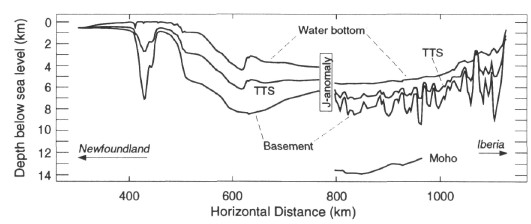
Figure 1. Cross section of the Newfoundland and Iberia Abyssal Plain conjugate margins, showing basement depth, water depth, total tectonic subsidence (TTS), and Moho depth (where observed). Horizontal distance is arbitrary and is meant only for scale. The narrow basin at about 400 km is the Jeanne d'Arc Basin. The shorelines of Newfoundland and Iberia are just off the figure to the left and right, respectively. Newfoundland Margin data were digitized from maps by Tucholke et al. (1982) and Tucholke and Fry (1985); Iberian Margin data were digitized from a profile by Whitmarsh et al. (1993). The two profiles are reconstructed to depict the J anomaly interpretation of the ocean/continent boundary location.
![]()