![]()
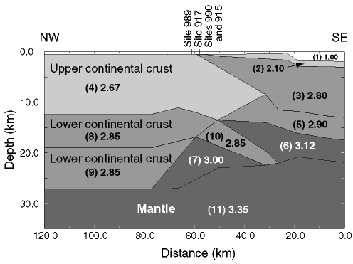
Figure 8. Crustal structure of the Southeast Greenland margin at 63°N, as modeled from reflection seismic and regional gravity data by H.C. Larsen et al. (1998). The model shown is the one preferred by H.C. Larsen et al. (1998) of two possible models; more recent wide-angle seismic data have confirmed that it is the best one (T. Dahl-Jensen, pers. comm., 1997). Numbers in parentheses are the original numbers of the crustal segments defined by H.C. Larsen et al. (1998), and the succeeding numbers are the densities used to fit the modeled gravity to the measured gravity. Oceanic crustal segment number 3 consists of SDRS with known thicknesses of up to 7 km plus ~2 km of dikes. Crustal segments numbers 5 and 6 are cumulates, and the boundary between them is arbitrary. Crustal segment number 7 is interpreted as igneous underplated material, and segment number 10 as a semidetached sliver of the lower continental crust. The thickness of the layers of the oceanic crust modeled by the geophysical data shown, and modeled by the calculations based on geochemical data as described in the text, are compared in Table 3. See text for details.
![]()