![]()
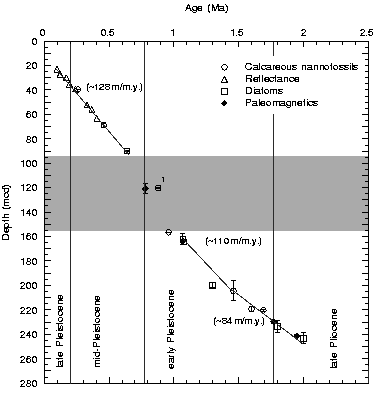
Figure F20. Age-depth plot of control points at Site 1089, integrating biostratigraphy, geomagnetic polarity, and color reflectance data from Holes 1089A-1089C. Plotted are the mean sample composite depths. The dark shading indicates the depth range of the disturbed sedimentary section between 94 and 156 mcd. Vertical error bars indicate approximate depth uncertainty in the geomagnetic polarity and diatom datums. The solid line represents a visual best fit through the control points (Table T9, p. 70). Corresponding sedimentation rate averages are given in parentheses. 1 = LO of R. asanoi.
![]()