Plate Boundary
"The
narrow-gutted but lofty archipelago of New Zealand, consisting of two large and
many smaller islands, rises from a system of relatively shallow submarine rises
and plateaux between the South West Pacific Ocean and the Tasman Sea. (This
mountainous region is).... part of a complex system that extends north to
Melanesia, then westward to the Indonesian archipelago and northward to Japan
and beyond as the geographic manifestation of the Circum-Pacific Mobile
Belt."
Charles A.
Fleming (1975)
C. February 1770 pen sketch of "a mountain of stupendous height, which was covered with snow," when Resolution was 6 leagues offshore from the mouth of the Clarence River.3 Mt. Tapuae-o-Uenuku (2885 m), the highest peak of the Inland Kaikoura Range, is viewed across the northward-declining heights of the coastal Seaward Kaikoura Range. These ranges are bounded by the major transcurrent Wairau, Awatare, and Clarence Faults, which splay northeastward from the Alpine Fault to link to the Hikurangi subduction margin.4
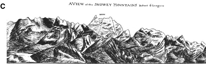
3Attributed
by Begg and Begg [1969] to Captain James Cook.
4Add
7085, Folio 31, Drawing 2. Digital image provided courtesy of the British
Library.
![]()