![]()
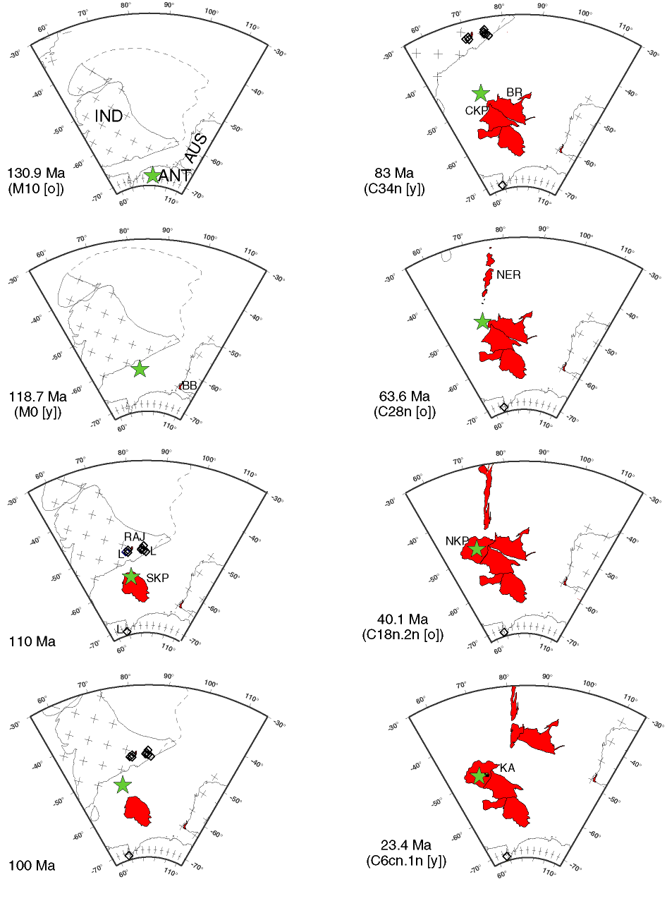
Figure F2. Plate reconstructions of the southern Indian Ocean region (after Royer and Coffin, 1992; Royer and Sandwell, 1989) using a hot spot reference frame (Müller et al., 1993) and keeping Antarctica fixed. Reconstructed position of the Kerguelen hot spot (after Müller et al., 1993) is indicated by stars. Volcanic rocks associated with the Kerguelen plume, as it has appeared through geologic time, are indicated in red shading, and lamprophyres (southeast India and Antarctica) (at 110 Ma) are indicated as diamonds. Dashed line denotes a possible northern boundary for Greater India. IND = India; ANT= Antarctica; AUS = Australia. 130.9 (M1O [o]) and 118.7 (MO [y]) Ma: Seafloor spreading initiates during Chron M11 (~133 Ma) between Western Australia and Greater India. The Bunbury Basalt (BB) of southwest Australia is erupted close to these breakup events in both time and space. Of the two Bunbury Basalt types, the Casuarina may be related to the breakup of Australia and India, influenced by the Kerguelen hot spot, and the Gosselin may represent magmatism associated with the breakup of Australia and Antarctica. Between 130.9 and 118.7 Ma, Antarctica migrates to the southeast relative to the Kerguelen hot spot. 110 and 100 Ma: Seafloor spreading continues among India, Antarctica, and Australia. Rajmahal (RAJ) volcanic rocks postdate breakup of India and Australia by ~15 m.y. (Markl, 1974, 1978) and the breakup of India and Antarctica by ~15-40 m.y. Indian and Antarctic lamprophyres (diamonds) also postdate major breakup events. The first massive pulse of Kerguelen magmatism creates the southern Kerguelen Plateau (SKP) (Figs. F3, F4) at ~110 Ma, as Indian Ocean lithosphere migrates southeast relative to the Kerguelen hot spot. 83 (C34n [y]) and 63.6 (C28n [o]) Ma: India continues its northward drift relative to Antarctica, and the Kerguelen hot spot is predicted to have remained close to the northeast edge of the central Kerguelen Plateau (CKP) (Figs. F3, F4) and Broken Ridge (BR) (Figs. F5, F6), which form at ~85 Ma. Subsequently, the hot spot generates the Ninetyeast Ridge (NER). 40.1 (C18n.2n [o]) and 23.4 (C6cn.1n [y]) Ma: At ~40 Ma, seafloor spreading commences between the CKP and BR. The hot spot generates the northern Kerguelen Plateau (NKP) (Figs. F3, F4), and since 40 Ma, as BR and the Kerguelen Plateau continue to separate, produces the Kerguelen Archipelago (KA), Heard and McDonald Islands (Figs. F3, F4), and the chain of volcanoes between Kerguelen Archipelago and Heard (Figs. F3, F4).
![]()