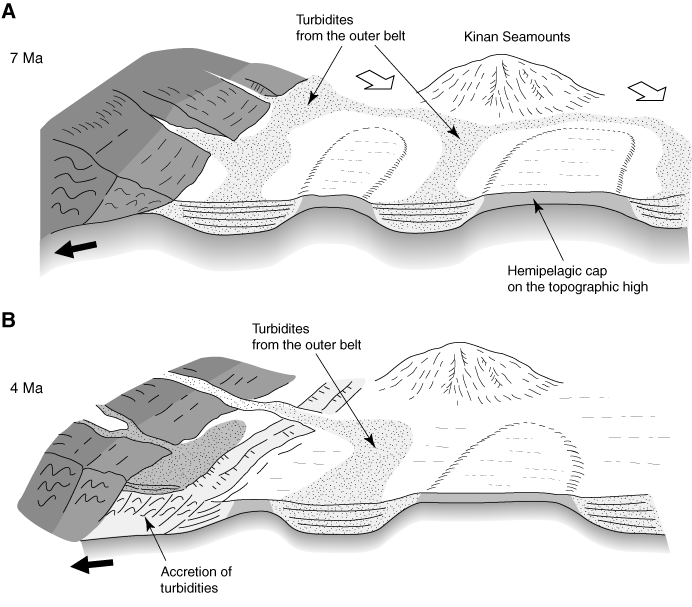
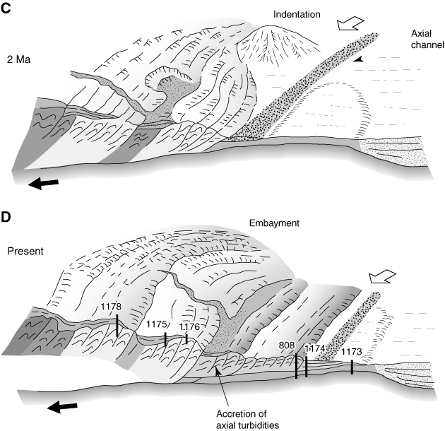
Figure F9. A series of cartoons illustrating the sedimentary and structural evolution of the central Nankai Trough of Shikoku based on DSDP/ODP Leg 87, 131, 190, and 196 data (not to scale). The subducting seamount is ~40 km in diameter at its foot and 3 km high, estimated from seismic data by Kodaira et al. (2000). The seafloor topographic highs and lows are related to the spreading fabric, transform faults, and later igneous activity associated with the final episode of Shikoku Basin spreading (north-south spreading direction) and the later near-axis Kinan Seamount igneous activity (Okino et al., 1994). The vertical height of those irregularities is ~0.5–2 km. A. At 7 Ma, turbidites derived from the Outer Belt of Shikoku were distributed (open arrows) into topographic lows on the Shikoku Basin floor. The topographic highs with relatively flat summits were covered by hemipelagic sediments. The subduction of the Shikoku Basin was presumed to have started at ~8 Ma, and the landward slope of the Nankai trough is mostly composed of the old accretionary prism (Shimanto Belt). B. At 4 Ma, accretion of the turbidites had built a substantial accretionary prism (sampled at Site 1178). The supply of the turbidites from the Outer Belt (open arrows) continued through that time as the seamount approached the trench.
C. By 2 Ma, accretion of the turbidites from the Outer Belt was complete
(sampled at Sites 1175 and 1176). The collision of the seamount had created an
indentation of the accretionary prism just northeast of the Muroto Transect. A
major shift of trench turbidite provenance took place at ~2 Ma and axially fed
turbidites from the Izu-collision zone in the central Japan started to fill the
trench axis. D. From 2 Ma to present, rapid accretion of axial
trench turbidites dominated at Sites 808 and 1174. Subduction of the topographic
high along the Muroto Transect has changed the style of deformation in the
accretionary prism because it lacks a thick turbidite section, being covered
instead with relatively thin hemipelagics (Sites 808, 1173, and 1174). The
seamount to the north has been subducted beneath the accretionary prism,
producing a large embayment. The locations of the Leg 190 and 196 drill sites
are shown in their present structural setting.