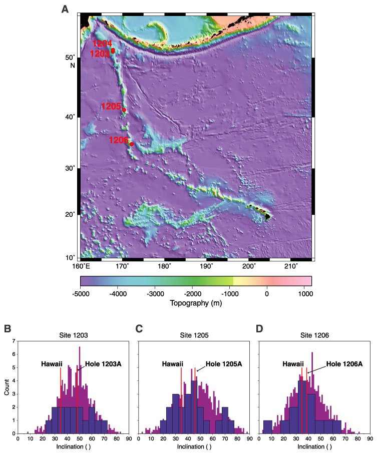
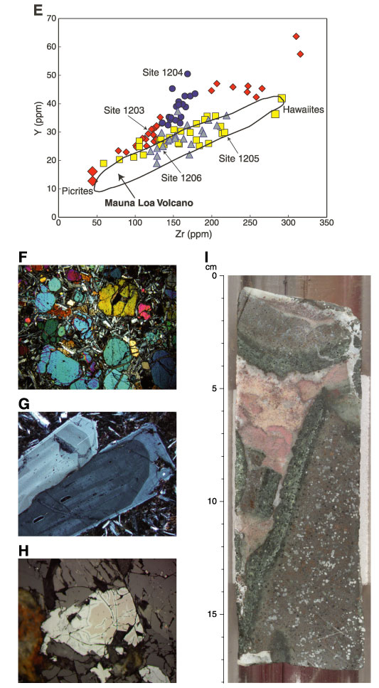
Frontispiece. A. Seafloor topography of the Hawaiian-Emperor volcanic chain in the northwest Pacific Basin (after Tarduno and Cottrell, 1997; Wessel and Smith, 1998). Leg 197 sites are labeled. B–D. Histograms of inclination values derived from principal-component analyses of stepwise alternating-field demagnetization data from lavas recovered at Leg 197 sites (blue). These are compared with a synthetic Fisher distribution (purple) (Fisher, 1953) having the same precision parameter (k) as the experimental data. Red lines indicate the inclination value for Hawaii and the calculated inclination value for Leg 197 sites. E. Plot of Zr vs. Y for all Leg 197 basement shipboard geochemical data compared with Mauna Loa Volcano (data from Rhodes, 1996). F. Photomicrograph of the olivine-rich zone in basement Unit 16 (cross-polarized light; field of view = 5 mm) (Sample 197-1203A-37R-3 [Piece 1A, 10–13 cm]). G. Photomicrographs of zonation in plagioclase from basement lavas at Site 1203 (cross-polarized light; field of view = 1.25 mm) (Sample 197-1203A-35R-4 [Piece 1F, 47–49 cm]). H. Photomicrograph of maghemite alteration (white) of primary titanomagnetite (pink) in Site 1204 basalt (reflected light; field of view = 1.25 mm) (Sample 197-1204B-8R-3 [Piece 8, 55–57 cm]). I. Close-up photograph of interval 197-1203A-41R-2, 0–17 cm, showing partially altered glassy lobe margins with calcareous interlobe sediment.
References
Fisher, R.A., 1953. Dispersion on a sphere. Proc. R. Soc. London A, 217:295–305.
Rhodes, J.M., 1996. Geochemical stratigraphy of lava flows sampled by the Hawaii Scientific Drilling Project. J. Geophys. Res., 101:11769–11780.
Tarduno, J.A., and Cottrell, R.D., 1997. Paleomagnetic evidence for motion of the Hawaiian hotspot during formation of the Emperor Seamounts. Earth Planet. Sci. Lett., 153:171–180.
Wessel, P., and Smith, W.H.F., 1998. New, improved version of the Generic Mapping Tools released. Eos, 79:579.