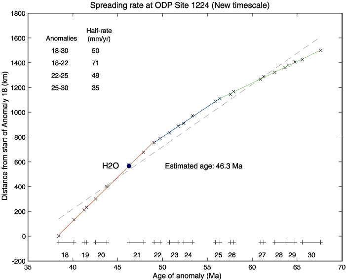
Figure F12. The Hawaii-2 Observatory (H2O) site lies on a normal band of oceanic crust with an estimated age of 46.3 Ma and a spreading half-rate of 71.0 mm/yr. On the magnetic lineation map of Malahoff and Handschumacher (1971) we drew a flow line perpendicular to the magnetic lineations in the ribbon of crust containing the Hawaii-2 cable track west of 140°W and between Anomalies 18 and 30. The geographic distances in kilometers along this line of the edges of the magnetic stripes relative to the start of Anomaly 18 are plotted as the ordinate of the graph in this figure. The ages of the magnetic stripes in units of million of years from Cande and Kent (1992, 1995) are plotted as the abscissa. The numbered bars above the abscissa indicate the normally magnetized chrons. The reversed chrons correspond to the gaps between the bars. Slopes on this graph give the spreading half-rate in kilometers per million years or millimeters per year. The average slope across all of the anomalies gives a spreading half-rate of 50 mm/yr, which agrees well with Malahoff and Handschumacher's value of 49 mm/yr. It is quite clear, however, that a better fit to the data is obtained by three straight lines for Anomalies 18-22, 22-25, and 25-30. The half-rates of these segments are 71, 49, and 35 mm/yr, respectively.