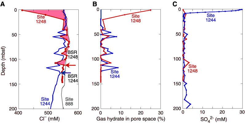
Figure F13. Chloride (Cl-) concentration profile at Site 1248 showing its relationship to the position of the bottom-simulating reflector (BSR) at the base of the GHSZ. Data from Sites 1244 and 888 are shown for comparison. A. Chloride concentration data from Site 1248 show excursions to fresher values superimposed on a near-vertical baseline. The red shaded portion presumably reflects dissociation of gas hydrate, which is most prevalent in the sediments above 20 mbsf. Interstitial chloride data from Sites 1244 (blue circles) and 888 (black circles) are shown for comparison. B. Estimates of the fraction of pore space occupied by gas hydrate at Sites 1248 (red) and 1244 (blue). Note that based on the available IW data, as much as 25% of the pore space at Site 1248 is occupied by gas hydrate in the uppermost sediments. Deeper in the sediments, 0% to 5% of sediment pore space contains gas hydrate that is apparently localized in specific horizons. C. Interstitial sulfate data from Sites 1248 (red) and 1244 (blue). Sulfate is present in the uppermost sediments at Site 1244 so that methane and, thus, gas hydrate is absent from near-surface sediments. However, at Site 1248 sulfate is absent in the uppermost sediments and methane is present in sufficient concentration to form gas hydrate, possibly reflecting upward fluid advection at this site. BSR = bottom-simulating reflector.