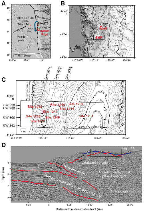
Figure F1. A. Location of Hydrate Ridge in the Cascadia accretionary complex. The path of sediments from the Columbia River, which form the Astoria Fan and fill the subduction zone trench, is also shown (blue arrow). Deep Sea Drilling Project (DSDP) Sites 174 and 175 originally documented the influence of the Astoria Fan on development of the accretionary complex. B. Detailed bathymetric map of the accretionary complex in the vicinity of Hydrate Ridge. This part of the accretionary complex is characterized by strong along-strike variability in topography, in contrast to the region to the north, which is characterized by long, linear ridges. The location of ODP Site 892, drilling on northern Hydrate Ridge in 1992, and the limits of the 3-D seismic survey discussed in this paper are shown. SHR = southern Hydrate Ridge. C. Detailed topographic map in the vicinity of the 3-D seismic survey. Contour interval is 20 m. Locations of drill sites for Leg 204 and the position of seismic lines shown in this paper are shown. Line numbers within the 3-D volume extend from 200 at the northern edge of the survey to 350 at the southern edge and from 100 at the western edge to 833 at the eastern edge. MBARI - Monterey Bay Aquarium Research Institute. D. Depth-converted seismic section from the site survey for Leg 146 (Tréhu et al., this volume). Box shows area detailed in Figure F4A.