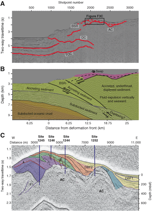
Figure F3. A. Seismic Profile OR89_Line2 through south Hydrate Ridge from the site survey conducted for Leg 146 (MacKay et al., 1992). Box shows the location of the section shown in C. The subduction zone décollement (DC), top of oceanic crust (TOC), accretionary complex (AC), and bottom-simulating reflector (BSR; dashed) are shown. B. Interpreted seismic section from A converted to depth using the velocity model of Gerdom et al. (2000), which was derived from large-aperture data recorded on ocean-bottom seismometers. Abyssal plain and accreted sediments are shown in shades of green; slope basin sediments are shown in light pink. C. Slice from the 3-D seismic survey coincident with the seismic section in A. Overlay shows seismic stratigraphic units discussed by Chevallier et al. (this volume). A, B, and B´ are bright reflections that were found to correspond to relatively coarse grained strata containing volcanic ash; AC indicates older, more lithified and fractured accreted sediments, which are overlain by uplifted and slightly deformed slope basin sediments; DBF1 and DBF2 are large debris flow deposits that indicate abrupt burial events, which may have affected gas hydrate stability; U is a regional unconformity that results from a migrating locus of uplift; F1 is a landward-vergent thrust fault from an earlier stage of accretion (adapted from Chevallier et al., this volume). Although structural details of the accretionary history of AC are not well imaged, the total volume of sediment that has undergone accretion, subduction, duplexing, and underplating can be determined from these data.