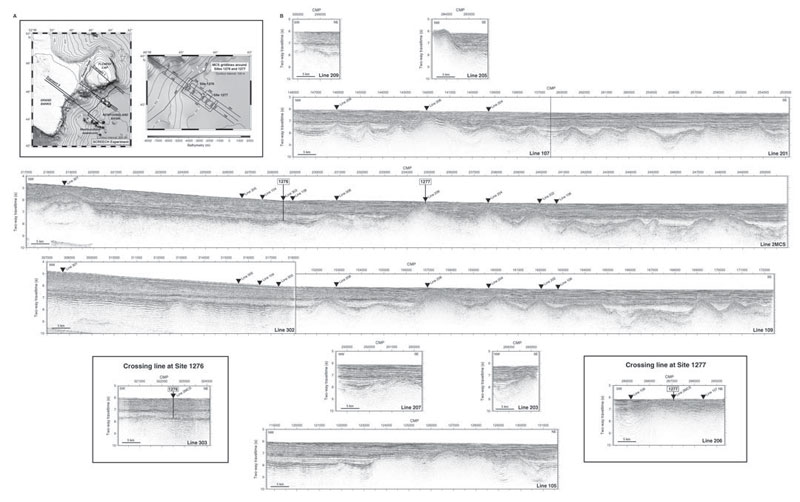
Figure F8. A. Studies of Continental Rifting and Extension on the Eastern Canadian Shelf (SCREECH) experiment location maps. Bathymetric maps showing the locations of multichannel seismic (MCS) reflection profiles acquired during SCREECH. White stars = locations of Sites 1276 and 1277. The map at the far left shows the entire SCREECH experiment, and the map at right shows a close-up of the SCREECH transect 2 MCS grid around Leg 210 drill sites. B. SCREECH line 2MCS and parallel MCS lines showing prestack time-migrated, multichannel seismic (MCS) dip-line reflection profiles from the seaward portion of the SCREECH transect 2 survey. Line 2MCS crosses both Sites 1276 and 1277. The profiles are arranged according to their location within the MCS grid, shown on the bathymetric maps at the left. Line number is indicated in the lower right-hand corner of each profile. Inverted solid triangles = intersections with margin-parallel MCS strike lines. Two of these strike profiles that cross line 2MCS at Sites 1276 and 1277 are shown at the lower left and lower right, respectively. All profiles are labeled by common midpoint (CMP) number, and a map with CMP navigation is available (see the "Supplementary Materials" contents list). Additionally, a description of data processing and plots of prestack time migrations of all sections from this grid are available (see "Data Processing and
Description"
and Figs. F3 and F4). (This figure is available in an
oversized format.)