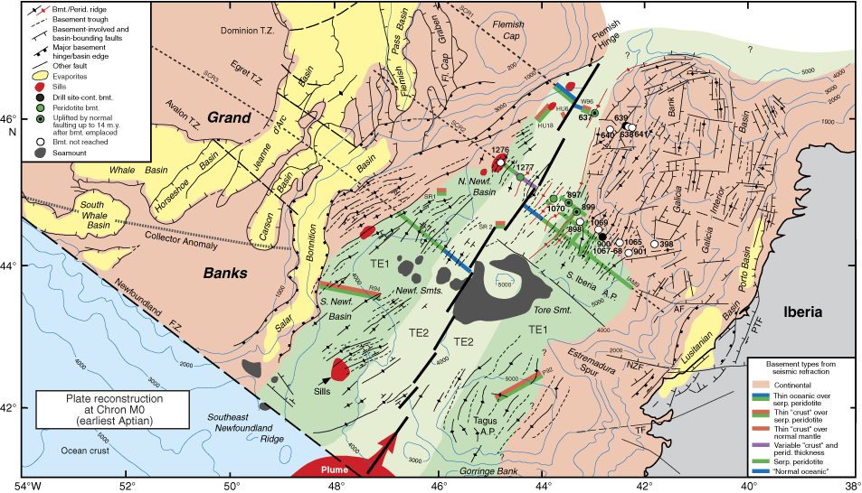
Figure F1. Reconstruction of the Newfoundland-Iberia rift at Chron M0 (~125 Ma, earliest Aptian), modified from Shipboard Scientific Party (2004). Present-day bathymetric contours (blue) are in meters. Continental crust is pale red, and yellow shows basins within continental crust that contain significant uppermost Triassic to Lower Jurassic evaporite deposits. DSDP and ODP drill sites are shown and coded according to whether they reached apparent continental basement (black), peridotite basement (green), or no basement (white); sites with good evidence that peridotite basement was faulted and uplifted 3–14 m.y. after it was emplaced have black dots at symbol centers. Peridotite ridges are marked by red lines with diamond symbols. Seismic refraction lines that constrain the distribution of basement types are shown by dotted lines, and colored bars and are explained in the box at lower right. The grid of lines at the southwest corner of the Galicia margin are CAM data. Thin "crust" shown by orange bars could be either magmatic ocean crust or serpentinized mantle, whereas blue bars show where velocity, layer thickness, and/or reflection characteristics suggest the presence of magmatic ocean crust. Data sources: SCR1 (SCREECH Line 1, Funck et al., 2003; Hopper et al., 2004), HU (Hudson profiles, Todd and Reid, 1989), W96 (Whitmarsh et al., 1996b), SCR2 (SCREECH Line 2, Van Avendonk et al., 2006; Shillington et al., 2006), CAM (Chian et al., 1999), IAM9 (Dean et al., 2000; Pickup et al., 1996), SR (Srivastava et al., 2000), R94 (Reid, 1994), P92 (Pinheiro et al., 1992). TE1 (darker green) shows conjugate zones of transitional extension reaching up to about anomaly M4 (Hauterivian/Barremian boundary); we interpret this as an interval of mantle exhumation. TE2 (lighter green) shows conjugate zones of subsequent transitional extension. We interpret this interval also to have been dominated by mantle exhumation, probably with a variable magmatic component, that reached to near the Aptian/Albian boundary (~112–110 Ma; i.e., to limits younger than shown in the reconstruction). See text for discussion. Red area at the southern edge of the rift schematically indicates a mantle plume that is interpreted to have constructed the Southeast Newfoundland Ridge, conjugate basement highs now incorporated in the western part of Gorringe Bank, and basement ridges reaching north and south along the plate boundary (e.g., J Anomaly Ridge, Madeira-Tore Rise) (Tucholke and Ludwig, 1982; Tucholke et al., 1989). This magmatism appears to have occurred from about the time of Chron M4 (latest Hauterivian) to younger than Chron M0, peaking at M1–M0 (late Barremian–earliest Aptian) (Tucholke and Ludwig, 1982). Red areas in the Newfoundland Basin indicate postrift sills intruded in ~Aptian–Albian sediments; these are interpreted from seismic reflection data and have been drilled at Site 1276. A.P. = abyssal plain, T.Z. = transfer zone, F.Z. = fracture zone. NZF = Nazaré Fault, PTF = Porto-Tomar Fault, AF = Aveiro Fault.