
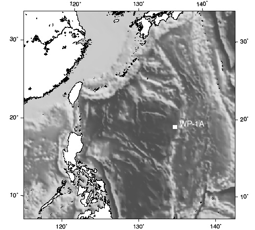
Leg 195West Pacific Seismic NetworkThe proposal for the Western Pacific Geophysical Network called for two sites which were endorsed by the International Ocean Network (ION). The long-term ocean seismic observatory network was included as an initiative in the ODP Long Range Plan (LRP) as a contribution to the Global Seismic Network. The GSN has been successful is resolving the earth’ss interior from land and island based seismic installations, but still lacks coverage in large areas of the oceans. Two Western Pacific sites are designed to aid study of earthquake dynamics, the dynamics of the subducting plates, the formation of island arcs, and the relation of these processes to mantle convection. The first of the sites is scheduled for drilling during FY 00 and the second is scheduled here for drilling in 2001. Long-term seismic observatories will be installed at both sites. Both observatories will be connected to nearby telecommunications cables, in future. A quiet and stable borehole will be drilled for installation of the long-term seismic observatory. A logging program is planned to measure the quality of the borehole The logging program will measure physical properties, anisotropy, and hole shape, similar to what was done at pilot site OSN-1 during Leg 136. Logs must be acquired prior to installation of any downhole instrumentation. The laterolog will measure resistivity in basement intervals. Standard geophysical logs will measure physical properties; hole volume can be estimated with high accuracy using the BHTV log in the basement intervals. This will improve grouting procedures for the strain sensors and emplacement for the seismometers. High-resolution temperature logs will be used to identify permeable zones and in-flow/out-flow from both drilling-induced and natural fractures in the holes.
 Drilling Plan A quiet and stable borehole is required for installation of the long-term seismic observatory. The logging program will measure physical properties, anisotropy, and hole shape, similar to what was done at pilot site OSN-1 during Leg 136. Logs must be acquired prior to installation of any downhole instrumentation. The laterolog will measure resistivity in basement intervals. Standard geophysical logs will measure physical properties; hole volume can be estimated with high accuracy using the BHTV log in the basement intervals. This will improve grouting procedures for the strain sensors and emplacement for the seismometers. High-resolution temperature logs will be used to identify permeable zones and in-flow/out-flow from both drilling-induced and natural fractures in the holes.
Staff Scientist: Carl Richter Operations Schedule | Back to FY 01-02 Abstracts
|