
Leg 197Motion of the Hawaiian Hotspot During Formation of the Emperor Seamounts: a Paleomagnetic TestLeg 197 will test the hypothesis of southward motion of the Hawaiian hotspot by drilling 5 seamounts of the Emperor trend. The principal objectives are to obtain moderate penetrations of the basement (150-250 m) to obtain samples suitable for radiometric age and paleomagnetic paleolatitude determinations. A comparison of these dated paleolatitude values versus fixed- and moving-hotspot predictions form the basis of the proposed test. This sampling strategy will also allow us to address important geomagnetic questions that require paleomagnetic data from the Pacific plate, including the history of the time-average field and its paleointensity. The data will place fundamental constraints on the Late Cretaceous to early Tertiary motion of the Pacific plate. An improved picture of this motion history is needed if proxy climatic data from previous and future drill sites are to be used to define past latitudinal gradients. For additional information about the proposed science of Leg 197, see the original JOIDES proposal: "Motion of the Hawaiian Hotspot During Formation of the Emperor Seamounts: A Paleomagnetic Test" at http://www.earth.rochester.edu/pmag/odp-proposal523.html.
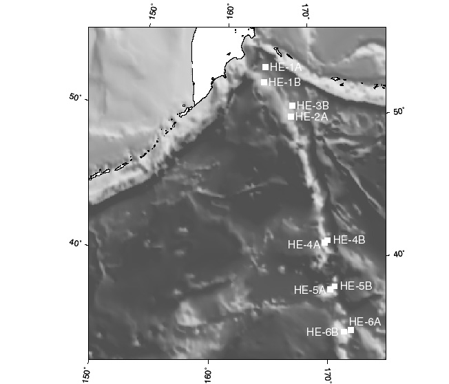 Drilling Plan Testing the hypothesis of southward motion of the Hawaiian hotspot will be accomplished by drilling 5 seamounts of the Emperor chain. The drilling is to achieve moderate penetrations of the basement for the purpose of obtaining samples suitable for determining radiometric age and paleomagnetic paleolatitude. The water depths at the proposed sites vary between 1300 - 3000 m with proposed penetrations between 40-1000 m of sediments (mostly silty clays, volcanic ashes, claystones) and 150 to 250 m basement rocks (basalt flows). The logging program will involve use of two standard tool strings (Triple-Combo / FMS-Sonic) and a magnetometer, requested as a third party tool. The log data are required mainly for core orientation to determine the dip of flow units to evaluate the possible effect of tectonic tilting. Magnetic/susceptibility tools may enable the definition of larger eruptive sequences if the mineralogy changed or if the magnetic field reversals occurred. The GHMT may be a useful tool, providing continuous magnetic susceptibility logs in the sediment section, and total field logs in both the sediment and basement. A downhole polarity stratigraphy is likely to be derived from the GHMT logs in the sediment sections. A large part of the basement section may be within the range of the susceptibility tool (it measures up to 1.6 x 10⁻² SI). The GPIT (inclinometry tool), run as an integral part of the FMS tool string, can also provide magnetic field data. If magnetic susceptibilities are expected to be higher, a third party magnetometer may be required, The resistivity tool has been the most valuable for the identification of single lava flows in the upper oceanic crust as well as in subaerial flood basalts.
Staff Scientist: Gary Acton Operations Schedule | Back to FY 01-02 Abstracts
|