
Leg 199 (used to be Leg 198 before 24 August 2000)Paleogene Equatorial Pacific TransectThe complex system of equatorial currents is one of the most persistent and clear traces of wind-driven circulation in the oceans. The unequal hemispheric thermal gradients in the modern oceans have pushed the Inter-tropical Convergence Zone (ITCZ) north of the equator and given rise to a narrow band of equatorial upwelling. This zone of upwelling and high productivity results in a high flux of biogenic debris within 1.5°-22° of the geographic equator, with peak values restricted to an even narrower zone. In the Pacific Ocean the rain of this debris has built, over geologic time, a mound of almost pure calcareous and siliceous sediments stretching along the equatorial region and reaching a thickness of over 500 m. The central equatorial Pacific is unique among the world's oceans in that the path of plate motions carries this linear trace of equatorial upwelling and productivity northward with time. There are two clear impacts of this northward plate motion: 1) the thickest part of the equatorial mound of biogenic sediment is displaced several degrees to the north of the equator and 2) sediments deposited a few tens of millions of years ago have moved completely out of the region of high sediment flux. This movement into regions of very low sediment accumulation (or even erosion) puts Paleogene equatorial sediments within the reach of the Ocean Drilling Program's APC/XCB technology. For the most part the sediments have never been subject to strong burial diagenesis and can be cored easily with little disturbance. Time intervals notorious for extensive chert formation (e.g. the middle Eocene) are more likely to contain only oozes because they have never been buried deeply. Over the last decade APC/XCB technology has been used to recover continuous Neogene sediment sections from the equatorial Pacific and to trace the variations in equatorial upwelling and biogenic flux during the transition from a one-pole ice age to a two-pole ice age. They have revealed intervals of very high flux rates linked with oceanographic and climatic change. The completely recovered Neogene sections have also been used to integrate biostratigraphy and paleomagnetic stratigraphy and have permitted the establishment of an orbitally tuned time scale back to 14 Ma. Leg 199 will take this coring technology back to the early Paleogene section, the time of the "hot house world." Leg 199 will collect a transect of Paleogene sediments in the eastern Pacific Ocean. The transect is to be centered on the approximate positions of the equator at 50-60 Ma and at 35-40 Ma. The main objective of the drilling will be a detailed investigation of the oceanographic consequences of the long term cooling since the beginning of the Eocene. Three related questions will also be addressed by this transect: 1) what has been the long-term history of the intensity of atmospheric circulation; 2) what has been the latitudinal movement of the intertropical convergence zone (ITCZ) - a key indicator of the relative temperature gradients in the northern and southern hemispheres; and 3) what has been the history of hydrothermal activity during the Eocene and how might it relate to either warm climates or chert formation? From earlier DSDP rotary coring it is predicted that many of the planned drill sites should have a hiatus or a radiolarian ooze/red clay interval from the Holocene until about the middle Miocene. Below the carbonate-poor interval, there will be lower Neogene and Paleogene calcareous oozes that will permit detailed reconstructions of Eocene sea surface temperature (SST) gradients and equatorial circulation and productivity. Northern sites in the proposed transect may contain only clays above the calcareous lower Eocene sediments. These sections are critical to mapping the movement of the ITCZ through time and to relating the extremely warm interval of the early Eocene to the history of hydrothermal activity. The southern sites are critical to mapping circulation changes during the rapid Eocene - Oligocene transition in calcareous sections.
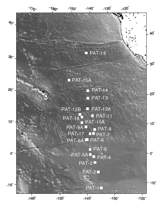 Drilling Plan The program consists of 11 primary APC sites. The objectives are 1) to study the paleoceanography of the Early Eocene warm climatic episode. Sites will be drilled on ~60 Ma crust to ensure the carbonates needed for productivity and SST (sea surface temperature) work are preserved (i.e. were deposited near the ridge-crest, above the CCD). This transect will delineate the evolution of equatorial current system (upwelling, productivity, temperature, etc.) for the purpose of understanding the causes of "hothouse"; 2) to track the position of the ITCZ (inter-tropical convergence zone), and the intensity of the trade winds, over the early Neogene and Paleogene. The position of the ITCZ will be determined from the composition of the aeolian fraction (Asian loess to the north and American andesitic ash to the south). Logs will be to delineate the stratigraphic position of the chert layers, and for precise depth matching of cored sections. The logs should also provide proxies for lithology and for characterization of in-situ physical properties. High-resolution resistivity measurements with the FMS tool may be useful for the quantification of sedimentary cycles. Chert layers are more likely to occur in the lower part of the boreholes, therefore within the reach of most logging tools - FMS images should pick out the resistive chert bands quite well.
Staff Scientist: Carlota Escutia Operations Schedule | Back to FY 01-02 Abstracts
|