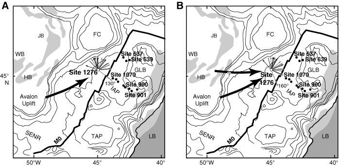
Figure F9. Unit vector plots of 11 ripple foreset dips (gray arrows) and the vector means for 11 grain-fabric determinations (black lines). In five cases where imbrication results defined a unique flow direction, the black lines have arrow heads indicating the paleoflow direction. In the other cases, the vector means are plotted to be as consistent as possible with the known flow directions, although the data do permit a 180° rotation of these vectors. Two cases are presented. A. The reference line is oriented downdip toward 130°. B. The reference line is rotated 30° clockwise to an azimuth of 160°. The M0 map is a cropped version of Figure F4. FC = Flemish Cap, GLB = Galicia Bank, HB = Horseshoe Basin, IAP = Iberia Abyssal Plain, JB = Jeanne d'Arc Basin, LB = Lusitanian Basin, SENR = Southeast Newfoundland Ridge, TAP = Tagus Abyssal Plain, WB = Whale Basin, ? = least likely dispersal pathway (originating in the vicinity of several rift basins on the Grand Banks).