![]() F1-16
F1-16
F1. Dependence of ice-sheet volume upon mean annual temperature (K) at sea level.

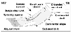
F2. Sequence model of deposition on shelf and slope through a glacial cycle.
F3. Schematic drawing of the processes active during glacial half-cycles.
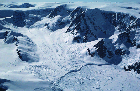
F4. Head of Lallemand Fjord showing flat, possibly peneplanated Antarctic Peninsula plateau.
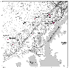
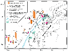
F5. Bathymetric chart of the Antarctic Peninsula Pacific margin with Leg 178 sites marked.
F6. CTD temperature and salinity profile, station CTD-09, with water masses labeled.

F7. Ages of ocean floor and ridge crest-trench collisions along the Antarctic Peninsula Pacific margin.
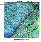
F8. GEOSAT GM mission satellite-derived free-air gravity map of the Antarctic Peninsula and southeast Pacific.
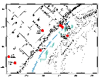
F9. Inner-shelf basin in Lobe 1 area, on seismic profile AI95-149, with mid-shelf high to the northwest.

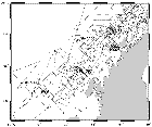
F10. Composite track chart of multichannel and single-channel seismic data used in selecting drill sites.
F11. Schematic figure of tectonic and glacial elements of the Antarctic Peninsula margin and Leg 178 sites.
F12. MCS profile AMG 845-08, showing glacial Sequence Groups S1 and S2 overlying Sequence S3, and S4.
F13. Deep-tow boomer profile of part of the outer continental shelf off Anvers Island.
F14. MCS profile IT92-109 through Drift 7 with Site 1096 marked.
![]()
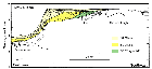
F15. GLORIA survey of northeastern Drifts D1 through D4 and intervening Channels I through IV.

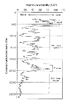
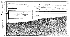
F16. Magnetic susceptibility from marine sediment core from Palmer Deep.