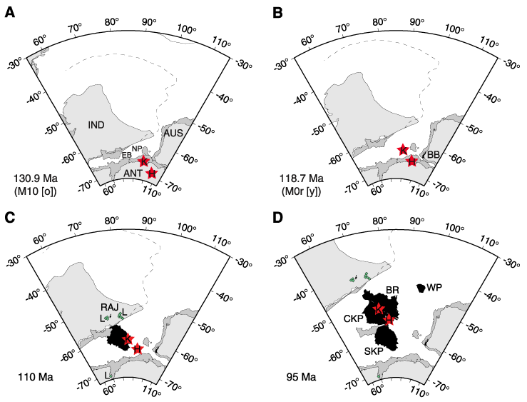
Figure F4. Plate reconstructions of the southern Indian Ocean region of Coffin et al. (2002), using the hotspot reference frame of Müller et al. (1993). Red stars = possible reconstructed positions of the Kerguelen hotspot (after Müller et al., 1993); those labeled "K" assume that the Kerguelen archipelago is the current location of the Kerguelen hotspot, and those labeled "H" assume that Heard Island is the hotspot's current location. Black shading = magmatism associated with the Kerguelen hotspot, diamonds = lamprophyres (labeled with "L" in 110 Ma panel) as they have appeared through geologic time (see Fig.
F1
for current locations of individual igneous complexes). Dashed line = a possible northern boundary for Greater India. IND = India, ANT = Antarctica, AUS = Australia. A, B. Seafloor spreading initiated at ~133 Ma between Western Australia and Greater India and at ~125 Ma between Australia and Antarctica. This model assumes breakup between India and Antarctica at ~133 Ma, although the timing of this event is not well known. The Bunbury Basalt (BB) of Southwest Australia erupted close to these breakup events in both time and space. Continental portions of Elan Bank (EB) and the Southern Kerguelen Plateau (unknown dimensions) remained attached to Greater India at these times. The Naturaliste Plateau (NP) also contains continental crust. C, D. Seafloor spreading continued between India, Antarctica, and Australia. The initial massive pulse of Kerguelen magmatism created the Southern Kerguelen Plateau (SKP), the Rajmahal Traps (RAJ), and Indian/Antarctic lamprophyres (L) from ~120 to ~110 Ma (Fig. F3) and may be linked to breakup and separation between Elan Bank and Greater India. The Central Kerguelen Plateau (CKP) formed between ~105 and ~100 Ma and Broken Ridge (BR) between ~100 and ~95 Ma (Fig. F3). Igneous basement of the Wallaby Plateau (WP) is not well characterized geochemically and has not been dated, but its age is inferred to lie between ~120 and ~100 Ma (Colwell et al., 1994).