![]() Figures F1-F10
Figures F1-F10
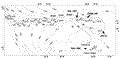
F1. Map of the western North Atlantic Ocean showing site locations.
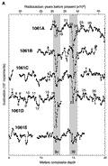
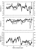
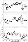
F2. Long-core inclination and declination measurements, Site 1061.
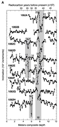
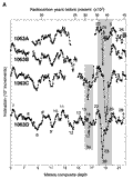
F3. Long-core inclination and declination measurements, Site 1062.
F4. Long-core inclination and declination measurements, Site 1063.
F5. Comparison of half-round and U-channel long-core paleomagnetic measurements, Hole 1061B.
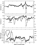
F6. Comparison of half-round and U-channel long-core paleomagnetic measurements, Hole 1061C.
F7. Comparison of half-round and U-channel long-core paleomagnetic measurements, Hole 1063C.
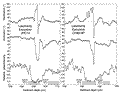
F8.
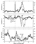
Comparison of excursion 3![]() as recorded in Holes 1061B and 1061C.
as recorded in Holes 1061B and 1061C.
F9. Paleomagnetic records of the Laschamp Excursion.
F10. Bulk sediment accumulation rates for Stages 1-4.