![]()
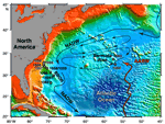
F1. Map of the western North Atlantic showing Leg 172 sites.
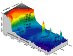
F2. Leg 172 site positions relative to bathymetry of the western North Atlantic.
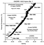
F3. Position of Leg 172 sites with respect to water masses in the western North Atlantic.
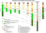
F4. Generalized lithostratigraphy, biostratigraphy, and magnetostratigraphy of Leg 172 sites.
T1. Operations summary, Leg 172.
T2. Drilling results, Leg 172.
![]() Figures F1-F4
Figures F1-F4
![]() Tables T1-T2
Tables T1-T2