Frontispiece.
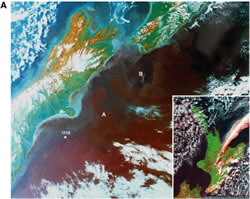 A. Coastal infrared satellite image of eastern New Zealand. Site 1119
is located near the junction between warmer subtropical water (blue) and colder
subantarctic (magenta) water masses, which are separated across the Southland
Front and are both northward traveling. Also marked are (A) the passage of both
water bodies through the Mernoo Gap, east of Banks Peninsula, and (B) a small
eddy spawned from the Wairarapa Eddy at the southern end of the south-traveling
East Coast Current.1 Inset: satellite
view from 650 km of the eruption of 17 June 1996 from Mt. Ruapehu, central North
Island. Note the characteristic east-turning dispersion of the ash plume.2
A. Coastal infrared satellite image of eastern New Zealand. Site 1119
is located near the junction between warmer subtropical water (blue) and colder
subantarctic (magenta) water masses, which are separated across the Southland
Front and are both northward traveling. Also marked are (A) the passage of both
water bodies through the Mernoo Gap, east of Banks Peninsula, and (B) a small
eddy spawned from the Wairarapa Eddy at the southern end of the south-traveling
East Coast Current.1 Inset: satellite
view from 650 km of the eruption of 17 June 1996 from Mt. Ruapehu, central North
Island. Note the characteristic east-turning dispersion of the ash plume.2
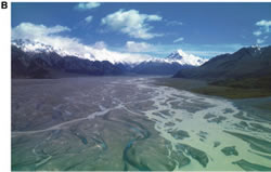 B. Eastern New Zealand Sedimentary System (ENZOSS), the source. View
northwest up the braided Tasman River, outwash train from the Tasman Glacier,
located east of the high peak of Mt. Cook (3754 m), the highest peak of the
Southern Alps mountain range, the western side of which coincides with the
Alpine Fault and the boundary between the Pacific and the Australian plates.
Click on images for individual enlargements.
B. Eastern New Zealand Sedimentary System (ENZOSS), the source. View
northwest up the braided Tasman River, outwash train from the Tasman Glacier,
located east of the high peak of Mt. Cook (3754 m), the highest peak of the
Southern Alps mountain range, the western side of which coincides with the
Alpine Fault and the boundary between the Pacific and the Australian plates.
Click on images for individual enlargements.
THE SCIENCE
SETTING: THREE RECONCILABLE VIEWS?
Plate Boundary
"The
narrow-gutted but lofty archipelago of New Zealand, consisting of two large and
many smaller islands, rises from a system of relatively shallow submarine rises
and plateaux between the South West Pacific Ocean and the Tasman Sea. (This
mountainous region is).... part of a complex system that extends north to
Melanesia, then westward to the Indonesian archipelago and northward to Japan
and beyond as the geographic manifestation of the Circum-Pacific Mobile
Belt."
Charles A.
Fleming (1975)
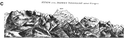 C. February 1770 pen sketch of "a mountain of stupendous height,
which was covered with snow," when Resolution was 6 leagues offshore
from the mouth of the Clarence River.3
Mt. Tapuae-o-Uenuku (2885 m), the highest peak of the Inland Kaikoura Range, is
viewed across the northward-declining heights of the coastal Seaward Kaikoura
Range. These ranges are bounded by the major transcurrent Wairau, Awatare, and
Clarence Faults, which splay northeastward from the Alpine Fault to link to the
Hikurangi subduction margin.4
C. February 1770 pen sketch of "a mountain of stupendous height,
which was covered with snow," when Resolution was 6 leagues offshore
from the mouth of the Clarence River.3
Mt. Tapuae-o-Uenuku (2885 m), the highest peak of the Inland Kaikoura Range, is
viewed across the northward-declining heights of the coastal Seaward Kaikoura
Range. These ranges are bounded by the major transcurrent Wairau, Awatare, and
Clarence Faults, which splay northeastward from the Alpine Fault to link to the
Hikurangi subduction margin.4
Passive
Margin
"A
transgression, which began in the early Upper Cretaceous, extended more and more
widely from time to time; and in many districts marine deposition went on
continuously or almost continuously (with local breaks only) throughout the
Tertiary era. Unconformities, some of them strongly angular, and also such
disconformities as have been discovered, are for the most part of limited
lateral extent, indicating only local emergence and erosion.... Though it is
unlikely that a complete section exists at any one place (in the area that is
now above the sea), it was long ago suspected that when evidence from many
scattered localities was pieced together a record would be available of beds of
every age from early Upper Cretaceous to Pliocene. With the help of micro-palaeontology
this goal is in sight; and it now seems even that the record continues through
Pleistocene into Recent time."
Charles A.
Cotton (1955)
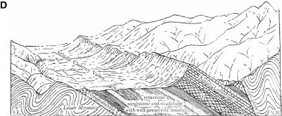 D.
Pen sketch by Sir Charles Cotton (1954), which summarizes the Cretaceo-Cenozoic
(Notocene; Kaikoura Synthem) stratigraphy of the New Zealand microcontinent. The
postrift sediment apron, shown here in a faulted inlier, comprises a Late
Cretaceouslate Eocene marine transgressive sequence that passes from
terrigenous inshore facies to offshore biopelagic radiolarian and nannoplankton
oozes. By the early Oligocene, the New Zealand landmass was almost entirely
submerged. Above the Amuri limestone, a thin succession of regressive
terrigenous sediment dips into and is truncated against the Clarence Fault, the
master structure along which the Inland Kaikoura Range was uplifted from the
Early Miocene onward.
D.
Pen sketch by Sir Charles Cotton (1954), which summarizes the Cretaceo-Cenozoic
(Notocene; Kaikoura Synthem) stratigraphy of the New Zealand microcontinent. The
postrift sediment apron, shown here in a faulted inlier, comprises a Late
Cretaceouslate Eocene marine transgressive sequence that passes from
terrigenous inshore facies to offshore biopelagic radiolarian and nannoplankton
oozes. By the early Oligocene, the New Zealand landmass was almost entirely
submerged. Above the Amuri limestone, a thin succession of regressive
terrigenous sediment dips into and is truncated against the Clarence Fault, the
master structure along which the Inland Kaikoura Range was uplifted from the
Early Miocene onward.
Global
Ocean Circulations
"Two
prominent global-scale ocean circulations, namely the thermohaline conveyor
belt and the Antarctic Circumpolar Current, are difficult to treat on an
individual or partial basis.... These two circulations interact extensively with
each other, via both mean and eddy flows; and the two are jointly affected by
thermohaline and wind forcing. Thus many ocean regions and processes are
significantly interdependent, and use of a global model is advisable."
A.J.
Semtner and R.M. Chervin (1992)
 E. Modeled flow field of the Australasian Southern
Ocean part of the global ocean,5
depicted as a time-averaged vector plot over 5 yr for a water depth range of
33005000 m and using a seasonal forcing simulation at 0.5° resolution. An
arrow of length 2° in latitude or longitude represents a transport of 5000 m
cm/s. Black = Australian, New Zealand, and Antarctic continents, white =
seafloor shallower than 3300 m. The model resolves well the strong flows of the
Antarctic Circumpolar and Deep Western Boundary currents, apart from an
underestimate of the amount of westward flow which occurs adjacent to the
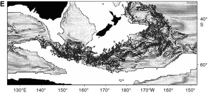
Hikurangi Plateau, northen edge of the New Zealand microcontinent.
E. Modeled flow field of the Australasian Southern
Ocean part of the global ocean,5
depicted as a time-averaged vector plot over 5 yr for a water depth range of
33005000 m and using a seasonal forcing simulation at 0.5° resolution. An
arrow of length 2° in latitude or longitude represents a transport of 5000 m
cm/s. Black = Australian, New Zealand, and Antarctic continents, white =
seafloor shallower than 3300 m. The model resolves well the strong flows of the
Antarctic Circumpolar and Deep Western Boundary currents, apart from an
underestimate of the amount of westward flow which occurs adjacent to the
Hikurangi Plateau, northen edge of the New Zealand microcontinent.
1
Image
PEL 701, Coastal Zone Color Scanner, Nimbus 7, Bands 1, 3, 6, taken 20 July
1979. Reproduced courtesy of the National Aeronautical and Space Agency [NASA].
2National
Oceanic and Atmospheric Administration [NOAA] Advanced Very High Resolution
Radiomenter [AVHRR] Image 14, received and processed by Landcare Research, New
Zealand.
3Attributed
by Begg and Begg [1969] to Captain James Cook.
4Add
7085, Folio 31, Drawing 2. Digital image provided courtesy of the British
Library.
5After
Semtner and Chervin, 1992, plate 9.