![]() Figures F1-F10
Figures F1-F10
![]() Figures F11-20
Figures F11-20
![]() Figures
F21-F30
Figures
F21-F30
![]() Figures
F31-F40
Figures
F31-F40
![]() Figures
F41-F50
Figures
F41-F50
![]() Figures
F51-F60
Figures
F51-F60
![]() Figures
F61-F70
Figures
F61-F70
![]() Figures
F71-F80
Figures
F71-F80
![]() Figures
F81-F90
Figures
F81-F90
![]() Figures
F91-F96
Figures
F91-F96
![]() Tables
T1-T21
Tables
T1-T21
F1. Satellite-derived free-air gravity map of the Kerguelen Plateau.
F2. Location of Site 1137 and site-survey data.
F3. Rig Seismic RS179/601 multichannel seismic profile across Site 1137.
F4. Composite stratigraphic section.
F5. Composite stratigraphic section for Hole 1137A from 0 to ~225 mbsf.
F6. Composite stratigraphic section for Hole 1137A from ~275 to 370.16 mbsf.
F7. Glauconite-bearing sandy packstone near and at the top of Unit III.
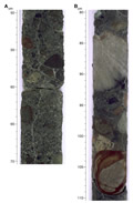
F8. Normally graded bed grading and cross-stratification in basement Unit 5.
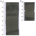
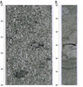
F9. Examples of conglomerates in basement Unit 6.

F10. Crystal-vitric tuff from basement Unit 9.
![]() Figures F1-F10
Figures F1-F10
![]() Figures
F11-20
Figures
F11-20
![]() Figures
F21-F30
Figures
F21-F30
![]() Figures
F31-F40
Figures
F31-F40
![]() Figures
F41-F50
Figures
F41-F50
![]() Figures
F51-F60
Figures
F51-F60
![]() Figures
F61-F70
Figures
F61-F70
![]() Figures
F71-F80
Figures
F71-F80
![]() Figures
F81-F90
Figures
F81-F90
![]() Figures
F91-F96
Figures
F91-F96
![]() Tables
T1-T21
Tables
T1-T21