![]() Figures F1-F4
Figures F1-F4
![]() Table
T1
Table
T1
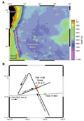
F1. Predicted topography of the northwest Pacific.
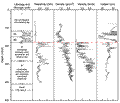
F2. Logging and coring results and core-log-seismic correlation.
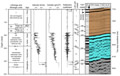
F3. Lithology and lithologic units and downhole measurements.
F4. SCS water gun lines 1, 2, and 3.
![]()
T1. Depth intervals, hole designations, and measurement type for the velocity and density data.
![]() Figures F1-F4
Figures F1-F4
![]() Table T1
Table T1