![]()
F1. Location of sites drilled along a shelf transect.
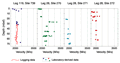
F2. Velocity data from the Prydz Bay and Ross Sea continental shelves.
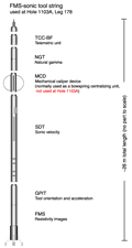
F3. Schematic of the FMS-sonic tool string used at Site 1103.
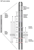
F4. Drawing of transmitter and receiver configuration of the SDT sonic velocity tool.
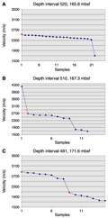
F5. Data categories for depth intervals.
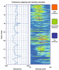
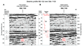
F6. Digital coherency mapping with resulting velocities.
F7. Summary plot of data categories.
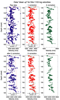
F8. Example of data reduction.
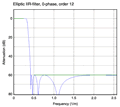
F9. Plot of a low-pass filter that removes short-wavelength variations.
F10. Reduced and filtered logging velocity data synchronized with depth-shifted resistivity data.
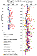
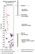
F11. Composite velocity profile, Site 1103.
F12. Velocity comparisons.
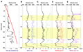
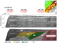
F13. Comparisons of time and depth section of line I95-152 in the vicinity of Site 1103.
T1. Transmitter/receiver spacings, SDT sonic velocity tool.
T2. Velocity categories.
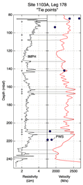
T3. Absolute depth shifts, Site 1103.
T4. Final depth vs. velocity and depth two-way traveltime data.
![]() Figures F1-F13
Figures F1-F13
![]() Tables T1-T4
Tables T1-T4