-
 , (1)
, (1)
 , and (2)
 , (3)
, (3)
Downhole measurements in Hole 1207B were made after completion of RCB coring to a total depth of 622.8 mbsf. Prior to logging, Hole 1207B was reamed, flushed of debris, and filled with 40 bbl of sepiolite mud. No tight spots were encountered during the reaming, and 40 m of soft fill was removed from the bottom of the hole. Three tool strings were run: the triple combo, the FMS-Sonic, and the GHMT (see "Wireline Logging" in "Downhole Measurements," Fig. F8, and Table T7, all in the "Explanatory Notes" chapter). The triple combo tool string (porosity, density, resistivity, and natural gamma radiation) was successfully lowered to 622 mbsf, within 1 m of the total hole depth, and logged up to the base of the pipe at 125.5 mbsf (Fig. F54). This logging run encountered a bridge at 173 mbsf but was able to pass through it, and no further bridges were encountered. The tools provided continuous and high-quality log data. The borehole diameter ranged from 10 in at the base of the hole, increasing to a maximum of 18 in toward the top of the logged section. The hole contained ledges that formed at the hard chert layers, with the relatively soft ooze in between preferentially washed away. After the main pass of this tool string, it was lowered down the hole again, but could not pass below 383 mbsf. The hole was logged from this point to the pipe with the Lamont-Doherty Earth Observatory multisensor gamma tool (MGT). The other tools in the tool string (the Schlumberger tools) had to be switched off during MGT logging.
The FMS-sonic logging tool string (microresistivity, seismic velocity, and natural gamma radiation) was lowered to 380 mbsf, where a bridge that had been encountered during the previous run prevented access to the lower reaches of the hole. Two passes of the dipole shear sonic imager tool were run in the monopole compressional and dipole shear data acquisition modes, the first with a medium frequency source, and the second with a low frequency source more suited to low-velocity formations.
The third logging tool string was the GHMT (magnetic field, magnetic susceptibility, and natural gamma radiation), which logged two passes from 370 and 355 mbsf to the base of the pipe. Unfortunately, a malfunction in the tool resulted in a collection of only partially useful logs. The symptom of the total magnetic field log was that it alternated between field values of ~32000 and 43000 nT, when it should have had only small variations around an average value of ~43000 nT. The susceptibility log has the same pattern as the core measurements in the interval of overlap, but its baseline is offset from zero (to ~500 ppm), and the log displays large negative peaks, both of which are very difficult to explain in terms of the known susceptibility of the sediments.
The wireline depth to seafloor was determined from the step increase in gamma ray values at the sediment water interface to be at 3110.5 mbrf; the driller's mudline depth used for establishing core depth was 3111.7 mbrf.
Hole 1207B was divided into six units on the basis of the logs (Figs. F55, F56).
Unit 1 is characterized by higher gamma radiation values than the underlying units and uniformly low resistivities. At its base is a peak in gamma radiation, density, resistivity, and photoelectric absorption factor, which corresponds to the Campanian-Miocene unconformity and manganese nodule layer.
Unit 2 is characterized by generally low gamma radiation values. The FMS images show that there are numerous layered cherts present in this interval (see "FMS Image Logs and Cherts"), increasing in frequency down the unit.
The top of this unit is distinguished by a downhole stepped increase in gamma radiation values, indicating perhaps more terrestrial material in this unit relative to the one above.
This unit is characterized by relatively higher gamma ray values, high densities and high resistivity values. There are five major peaks in density and resistivity within the unit, indicating well-lithified sediment or closely spaced chert layers.
Unit 5 has similar log characteristics to Unit 3. It has relatively low gamma radiation and density values.
Unit 6 is characterized by the highest gamma ray values in the logged section, caused mostly by uranium. Resistivity and density values are high, again indicating well-lithified sediment. This unit contains a 1.2-m-thick gamma radiation peak, which is associated with a Corg-rich black shale recovered in the lower Aptian part of the section.
The lower Aptian black shale recovered in Core 198-1207B-44R is clearly represented in the logs by a large peak in gamma radiation at 566 mbsf (Fig. F57). Uranium is the main contributor to the gamma radiation peak; uranium peaks are often associated with black shales because the uranium is adsorbed by the organic matter in the shale. The black shale is also apparent in other logs as low density values because of the low density of organic matter and as high porosity values because the porosity tool detects the amount of hydrogen in the formation, which is usually a good indicator of pore water content but is present here also in the organic matter.
The shale is ~1.2 m thick, according to the uranium, porosity, and density logs. The peak value in uranium occurs toward the top of the black shale interval. Approximately 40 cm of shale was recovered; thus, it appears that about two-thirds of the interval was not recovered.
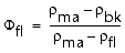
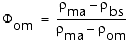
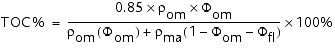
The total Corg content can be estimated from the density log. The result is only approximate because we assume that the shale and the background sediments have the same porosity and adopt values for some densities (e.g., of the organic matter) that are not well constrained. Following Rider (1996), we used the following three equations to find that the organic matter content is 23.3 wt% by volume and 17.7 wt% by mass. If the mass percent carbon in the organic matter is 85 wt%, then there is an average of 15 wt% TOC in the black shale at 566 mbsf, which is approximately the average of TOC measured by Rock-Eval pyrolysis (see "Carbonate and Organic Carbon" in "Organic Geochemistry").
where,
 bk = 23 g/cm3 = density of background sediment (from density log),
bs = 1.88 g/cm3 = density of black shale interval (from density log),
om = 1.2 g/cm3 = density of organic matter (assumed),
ma = 2.7 g/cm3 = density of matrix (grain density),
fl = 1.05 g/cm3 = density of seawater,
bk = 23 g/cm3 = density of background sediment (from density log),
bs = 1.88 g/cm3 = density of black shale interval (from density log),
om = 1.2 g/cm3 = density of organic matter (assumed),
ma = 2.7 g/cm3 = density of matrix (grain density),
fl = 1.05 g/cm3 = density of seawater,
 fl = water-filled porosity, and
om = volume fraction of organic matter.
fl = water-filled porosity, and
om = volume fraction of organic matter.
There are no other gamma radiation peaks of the same magnitude in the Cretaceous section at Hole 1207B. There are some smaller peaks, notably at 556 and 560 mbsf just above the main event and at 367 and 346 mbsf. The gamma radiation peak at 346 mbsf (Fig. F58) appears to be at or very close to the Cenomanian/Turonian boundary, which corresponds to a prominent oceanwide anoxic event that led to deposition of Corg-rich units globally. This peak might then represent a minor black shale at this site. However, hardgrounds also often have an associated uranium peak, and it is also possible that the peak represents a period of nondeposition. The thickness of this peak is ~60 cm, based on the high-resolution gamma radiation log of the MGT, and the amplitude is six times less than the peak at 566 mbsf (1.1 ppm compared with 6.4 ppm uranium). Unfortunately, uranium content is not usually a good quantitative guide to the organic matter content of the sediment.
Hole 1207B has very low core recovery from 217 mbsf to the total depth; most cores in this interval contain only pieces of chert. The FMS image logs, available from 148-380 mbsf, show a series of highly resistive thin beds alternating with lower resistivity layers (resistive beds appear light in the FMS image, and conductive beds appear dark) (Fig. F59). We attribute this layering to hard chert layers within soft ooze and chalk. The frequency of cherts increases downhole, reaching a maximum at 320 mbsf. The form of the cherts was predominantly layered (present in the images of all four of the FMS pads), rather than nodular (present in only one or two pad images at a particular depth).
The locations and thicknesses of the cherts were taken from the FMS images (Fig. F60). The dynamic image is better than the static image for this task because the color contrast over short intervals is enhanced. The chert layers also form small ledges in the hole, as shown by the reduction in hole diameter in the caliper logs (Fig. F59). The chert percentage for each chert/ooze alternation was calculated and is also presented in Figure F60.
The total count of chert layers is 214 layers between 200 and 380 mbsf, with the highest frequency being between 316 and 326 mbsf. The thickness ranges from 3 to 20 cm, with an average thickness of 8.8 cm.
Low core recovery in chalk-chert sequences has been the subject of much discussion (Keene, 1975). However, little information is available on the form, thickness, and distribution of chert layers. The logging data from this site provide an important basis for further discussions of core recovery in chalk/chert and ooze/chert alternating sequences.
We constructed a synthetic seismogram for Site 1207 using downhole and core physical properties measurements to date the various reflectors on the seismic section and to place the notable horizons identified in the core in their two-dimensional setting. Nearly continuous velocity and density measurements from the Hole 1207A cores were available to 217 mbsf. We used the Hamilton Frame (PWS3) velocities (see "P-Wave Velocities" in "Physical Properties") because they are typically more reliable than the MST P-wave values, and the MST GRA bulk densities (see "MST Measurements" in "Physical Properties"). Densities lower than 1.4 g/cm3 were removed from the data set because they typically result from section-end and void effects. For the downhole logs, velocity data were available from 120 to 360 mbsf, and density data were available from 125 to 612 mbsf. To complete the velocity profile, we calibrated the logarithm of the resistivity (medium induction phasor-processed resistivity [IMPH]) to the velocity measurements using a linear least-squares fit:
We found that the velocity log contained occasional bad values that caused spurious reflections in the synthetic seismogram, so we used the velocity derived from resistivity (a more robust measurement) for the whole interval (130-620 mbsf).
The synthetic seismogram was calculated using the IESX software by Schlumberger GeoQuest (Fig. F61), using the standard method described by Rider (1996), among others. The velocity and density data were converted from depth to two-way traveltime (TWT) using the interval velocities. Impedance (velocity x density) was calculated, and the impedance contrast between successive layers gave the reflection coefficient series. The source wavelet (-90° phase, extracted from the 20 seismic traces surrounding the hole location) was convolved with the reflection coefficient series to give the synthetic seismogram. The synthetic seismogram was stretched and squeezed slightly to line up the synthetic reflections with those in the seismic section to give the final version shown in Figures F61 and F62.
![]()