![]() Figures F1-F7
Figures F1-F7
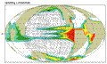
F1. Global land-sea distribution and annual-average map of upwelling into the thermocline.
F2. Net freshwater flux in centimeters and the seasonal cycle at 115°W.
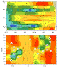
F3. Quantities averaged through the upper 30 m of the model.
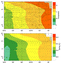
F4. Annual average temperature for the thermocline layer.
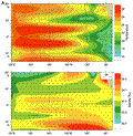
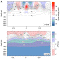
F5. Temperature, streamlines, salinity, and current vectors for 190-550 m.
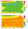
F6. Temperature, streamlines, salinity, and current vectors for 900-2000 m.
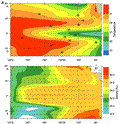
F7. Meridional transects along 115°W.