![]() Figures F1-F20
Figures F1-F20
![]() Figures
F21-F40
Figures
F21-F40
![]() Figures
F41-F53
Figures
F41-F53
![]() Tables
T1-T11
Tables
T1-T11
F1. Oceanic lithosphere drilling, 1968-2003.

F2. Basement age vs. depth of basement penetration.

F3. Depth of penetration subdivided by ocean basin.

F4. Depth of penetration clustered by spreading rate.

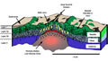
F5. Cross section of crust created by superfast seafloor spreading.
F6. Depth to axial low-velocity zone.

F7. Age map of the Cocos and Pacific plates.

F8. Isochrons inferred from magnetic anomalies.

F9. Reconstruction of Site 1256 at 14 Ma.

F10. Site survey track map, Site 1256.

F11. Site survey track map, Site GUATB-02.

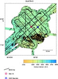
F12. Site survey track map, Site GUATB-01.
F13. Site survey track map, Site ALIJOS.

F14. MCS data from line 22.
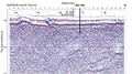
F15. MCS data from line 27.

F16. Velocity model based on inversion of refraction data.

F17. Location map of four holes drilled, Site 1256.

F18. Reentry cone and casing installed in Hole 1256D.
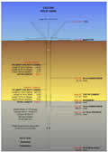
F19. Simplified lithostratigraphic column, Site 1256.

F20. Magnetostratigraphy from SEPs from split-core sections.

![]() Figures F1-F20
Figures F1-F20
![]() Figures
F21-F40
Figures
F21-F40
![]() Figures
F41-F53
Figures
F41-F53
![]() Tables
T1-T11
Tables
T1-T11