![]() Figures
F1-F9
Figures
F1-F9
F1. Relief map of the Nankai Trough.
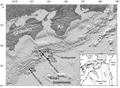
F2. Cross section along the Muroto Transect.
![]()
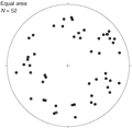
F3. Poles to faults and fractures from RAB imaging.
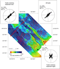
F4. Horst and graben structures on seismic image.
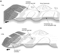
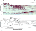
F5. Stratigraphy and structure of prism toe of Muroto Transect.
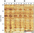
F6. Static-normalized RAB image for trench fill deposits.
F7. Consolidation model for upper and lower Shikoku Basin facies.
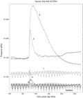
F8. Pressure time series recorded by ACORK in Hole 808I.
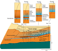
F9. Sedimentary and structural evolution of the central Nankai Trough.