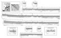
![]() Figures F1-F8
Figures F1-F8
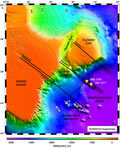
F1. Bathymetric map of the Newfoundland margin.
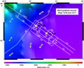
F2. Bathymetric map of the seaward part of SCREECH transect 2.
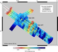
F3. Prestack time migration of SCREECH line 2MCS.
![]()
F4. Other MCS lines.
![]()
F5. Gridded picks of prestack time migrations.
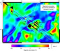
F6. Magnetic anomalies from the gridded data.
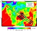
F7. Gridded Geosat free-air gravity data.
F8. SCREECH line 2MCS and parallel track lines with location maps.