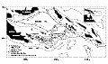
F1. Physiographic features and plate boundaries of Woodlark Basin region.
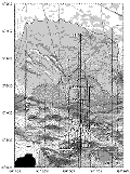
F2. Papuan Peninsula topography and western Woodlark Basin bathymetry showing relocated epicenters and earthquake focal mechanisms (Abers et al., 1997).
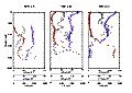
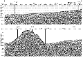
F3. Nested meridional cross sections at 151º34.5'E.
![]()
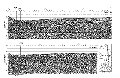
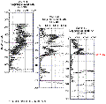
F4. Depth sections of seismic lines on which Sites 1108, 1112, and 1113 were drilled in the rift basin north of Moresby Seamount.
F5. Time section of seismic line on which Sites 1109-1111, 1114-1116, and 1118 were drilled.
F6. Time section of seismic line on which Site 1117 was drilled.
![]()
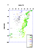
F7. Locations of Leg 180 drill sites and seismic tracks.
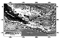
F8. Bathymetric map showing locations of Leg 180 drill sites near Moresby Seamount.

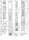
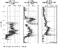
F9. Lithostratigraphy and correlation of Sites 1108, 1109, 1115, and 1118.
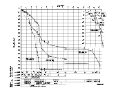
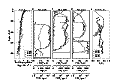
F10. Sedimentation curves based on nannofossil and foraminifer datum events, chron and subchron boundaries, and lithostratigraphic correlations.
F11. Porosity data for Sites 1108, 1109, 1111, 1114, 1115, 1116, and 1118.
F12. Magnetic susceptibility for Sites 1118, 1109, and 1115 aligned to the top of the Mammoth polarity event.
F13. Magnetic susceptibility for Sites 1118, 1109, and 1115 as a function of age.
F14. Biogeochemical profiles in sediments, Sites 1109, 1115, and 1118.
F15. Dissolved Ca2+, Mg2+, and SiO2 profiles at northern margin (Woodlark Rise) sites.