![]() F1-F9
F1-F9
![]()
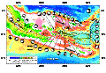
F1. Topographic image of Woodlark Basin region.

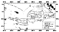
F2. Geophysical database for Woodlark Basin region.

F3. Topography, bathymetry, and seismicity of Papuan Peninsula-Woodlark Basin region.
F4. Seafloor magnetization of Woodlark Basin.

F5. Seafloor spreading magnetic lineations.
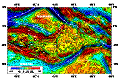
F6. Free-air gravity anomaly map.
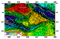
F7. Bouguer anomaly map of Woodlark Basin region.
F8. Site survey multichannel seismic data.
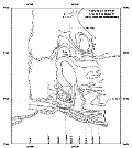
F9. Isopach map of synrift sediments.
T1. Data sources for geophysical compilations.